|
|
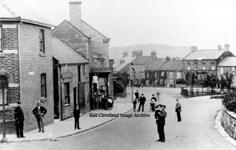
Now sadly painted over the former Police Station standing at the western end of Skelton High Street was a magnificent Victorian brick building; the Police Station was purchased from Skelton Castle Estate in 1921 by the then North Riding Constabulary. Bulmer’s Directory of 1890 lists Thomas Imeson as the Police Sergeant resident at the building; Kelly’s Directory of 1909 lists: “Sergeant Richard Benjamin Gamble + one Constable”, the building was superseded by a modern purpose-built building on Derwent Road in the late 1950s and subsequently closed. This postcard view shows a quieter road, the lady can push her pram up the near side of the road without risk; no thundering traffic then! Peter Appleton has further advised: “The old Police Station, more properly 1 South Terrace, is first recorded in the Skelton Castle Estates Rent book for Lady Day 1873 (25th March 1873) when a payment of £27.10s.0d was recorded. The entry bore the annotation “New”. The police presence there can be traced through successive censuses 1881-1911. The property was sold to the North Riding County Council in April 1921 for £620. The North Riding County Council sold the building in July 1963 to a Mr A E Danks. The police presence in Skelton, which started in August 1862, is described in more detail in my book: My Grandad was a “Felon”, pp 62-4”
Image and update courtesy of Peter Appleton.
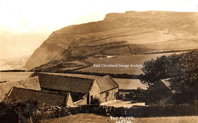
Entitled ‘The Cliffs, Loftus this postcard view over Hummersea farm and towards Boulby gives an excellent view of ”Snilah ponds” were believed to have been the settling ponds for Hummersea Alum works. Alas no longer visible, they were ‘filled-in’ in more recent times; older residents of Loftus have happy memories of looking for newts and similar wildlife in the ponds in their youth, happy days! Peter Appleton has updated our knowledge with: “No, not settling ponds for the alum works. There exists, among the Zetland papers at North Yorkshire County Record Office a sketch map (Ref.: ZNK/V/3/8/808) dated 8th April 1807 showing the arrangement for a system of drains and ditches to collect water and feed it into “Snarley Pond”. The outflow from the pond was shown as a “New Conductor for the water to the Alum House”. This was shown heading off in the direction of the Alum House complex on the beach at Hummersea. That Alum House complex was commissioned during the winter of 1809/10. The water was being gathered from source points all along the fields that lay adjacent to the cliff top and those to the south of the track that leads from present-day Hummersea House past Warren House and on towards Gallihowe.” Tom Sayers also remarks: “Famous for gold crested newts; Norman Lantsbery allowed the new Potash to fill in these historic ponds in exchange for widening the lane from Loftus to Street Houses. This would be a criminal offence today”.
Image and update courtesy of Peter Appleton; also thanks to Brian Pierce and Tom Sayers for the updates.
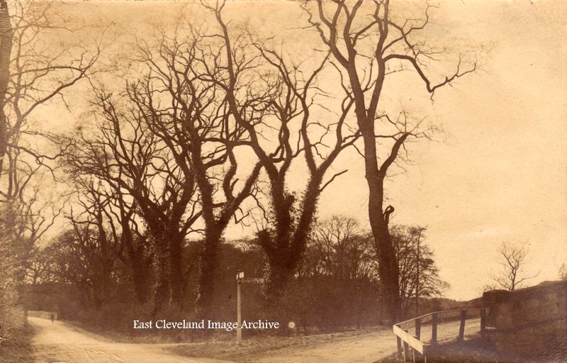
Situated in Skelton Ellers, the bridge to the right in this postcard view is of Upleatham bridge, built in 1755 it is Grade II listed. Similarly Ellers bridge which can be seen at the left, built in 1756 is also listed. Both bridges have stood the test of time, despite many ‘knocks’ over the years from passing motor traffic.
Image courtesy of Peter Appleton.
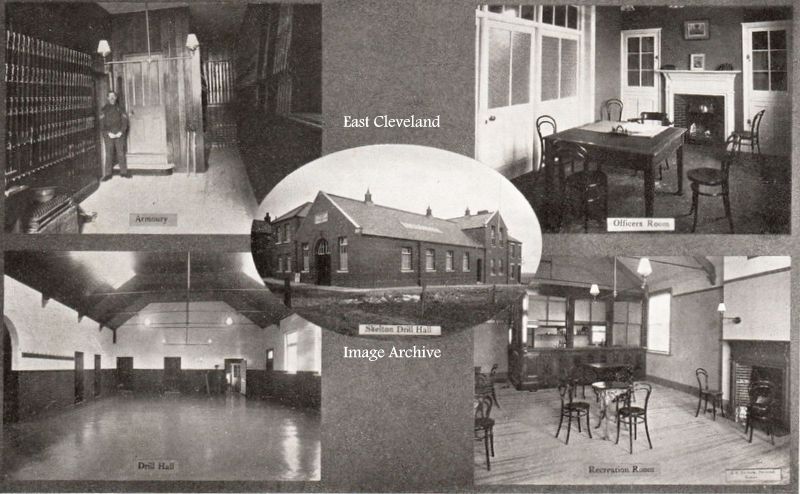
This postcard view of a building which will be remembered by many; internally it bears no resemblance to those views included in this image and externally is passed by many who are unaware of the buildings former essential use. Originally opened on 26th December 1913, for the Skelton Territorials “G” Company of the 4th Yorkshire Regiment, in the 1960s it became a social club. After burning down it was altered into apartments, bearing the title of Marlborough Court; it still stands at the southern end of Marlborough Road.
Image courtesy of Peter Appleton.
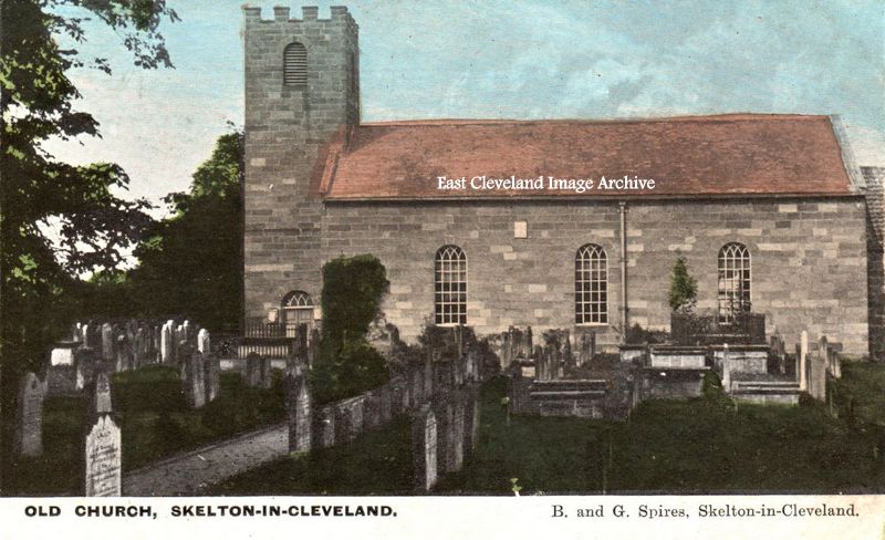
A postcard view of the old church of All Saints Skelton, from Skelton based B. and G. Spires; the Spires produced several hand-tinted postcard views of Skelton and the surrounding area during the early 1900’s. Peter Appleton tells us: “The original church was probably erected by one of the Fauconbergs, who inherited the Castle upon the death of Peter de Brus III without issue. His eldest sister, Agnes, married Walter de Fauconberg and thus the estate passed into the hands of that family, until their male line died out in 1407. The name on the Faculty for the pulling down and rebuilding the church is Joseph William Hall Stevenson, who inherited the estate from his father, John Hall Stevenson, in 1785. The rebuild cost £443.2s.7d according to the Church Wardens’ Accounts Book and took place during 1785 and 1786. The cost was covered by a donation of £100 from Joseph, the sale to the parishioners of the pews in the nave, east gallery (no longer extant) and west gallery, plus the sale to the local plumber of the lead recovered off the roof. Several other prominent citizens also signed the Faculty.” The interior retains many old fittings, including a three-decker pulpit. Part of an old 11th century stone sundial found in the church yard is now in the new church.”
Image and additional information courtesy of Peter Appleton.
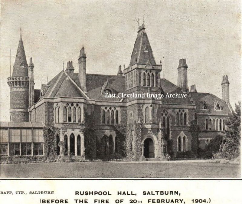
Rushpool Hall is one of the finest specimens of Victorian architecture to be found in North Yorkshire. It was constructed at the head of the valley gardens in Saltburn-by-the-Sea in the years 1863-4 for Mr John Bell, one of the Victorian pioneer Ironmasters of Bell Brothers a company that controlled and worked the ironstone mines at Skelton-in-Cleveland. It seems logical that the magnificent Rushpool Hall was built with the first ironstone raised from Bell Brothers Skelton Shaft mine. After John Bell died in 1888, Sir Arthur Dorman (of Dorman Long Iron & Steel Works) moved in. Sir Joseph Walton, coal mine owner, active Wesleyan Methodist and Liberal Party MP purchased the property after it was renovated in 1906 following the great fire in 1904. The Hall was almost destroyed when a maids candle accidentally caused a curtain to catch alight. The construction of the outer walls built from ironstone mined in the Bell brothers Skelton shaft mine is probably the main reason why the Hall survived the fire. It is today a hotel and premier wedding and function venue. This image produced by Rapp’s of Saltburn as a postcard, clearly titled as ‘Before the fire of 20th February, 1904’; it must have been very topical at the time!
Image courtesy of Peter Appleton, additional information courtesy of Rushpool Hall.
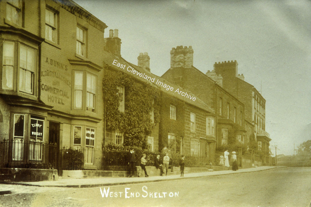
Still a familiar view of North Terrace, Skelton; this postcard view dates from the turn of the 2oth century. The Royal George whose host was A. (Albert) Bunn as recorded in the 1901 and 1911 Census; it is presumed that the Royal George lost the front railings in the First World War.Even today the building still exists, more as a ‘pub with good grub’; than a ‘commercial hotel’. Peter Appleton has assisted with further information regarding Albert Bunn: “Alfred Bunn was born at Abington, Cambridgeshire in 1850. He married Hannah Ord at Middlesbrough Register Office in 1878. He was a Coachman in Domestic service, living at 15 Stanhope Street, Saltburn in 1891. This is just round the corner from the Queen Hotel. Was he the hotel’s coachman, I wonder? By 1897 he was landlord of the Royal George and was elected a member of “Skelton Felons” (or Skelton Association for the Prosecution of Felons to give it its full title) in that year. In 1910 he was elected to the management committee of “the Felons” and is last mentioned in the Minute Book of the Association in 1915. He died in March 1917.”
Image courtesy of Peter Appleton and many thanks to Peter for the update.
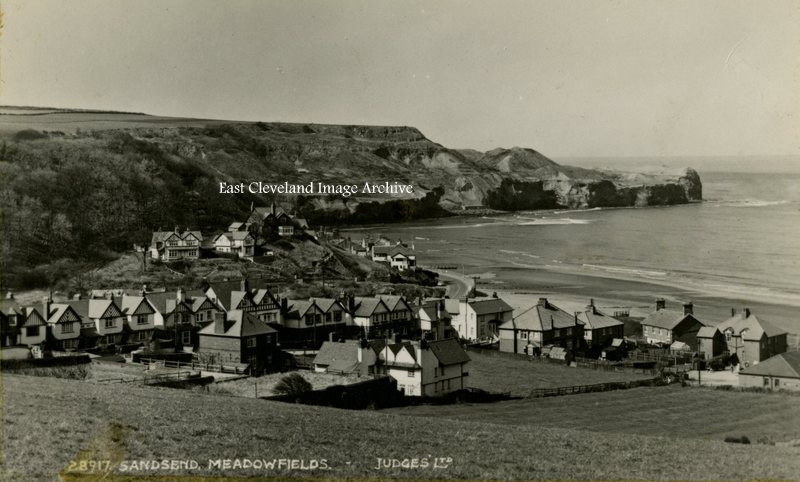
Meadowfields is actually part of East Row, being that part of Sandsend first encountered as the approach is made from Whitby; it is the houses leading off at a right angle from the road. It is only after crossing over East Row beck that Sandsend is properly entered; the view from a Judges postcard is minus the East Row viaduct which was demolished in 1960, following closure of the line in 1958.
Image courtesy of Iris Place.
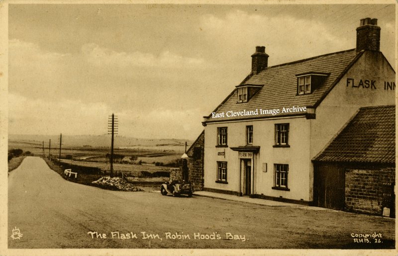
The Flask Inn, 7 miles from Whitby on the road to Scarborough is a former 18th century coaching inn . Now much altered with development and lying away from the realigned road. The opened topped sports car stands at the lone petrol pump, can any one identify the make of the car?
Image courtesy of Iris Place.
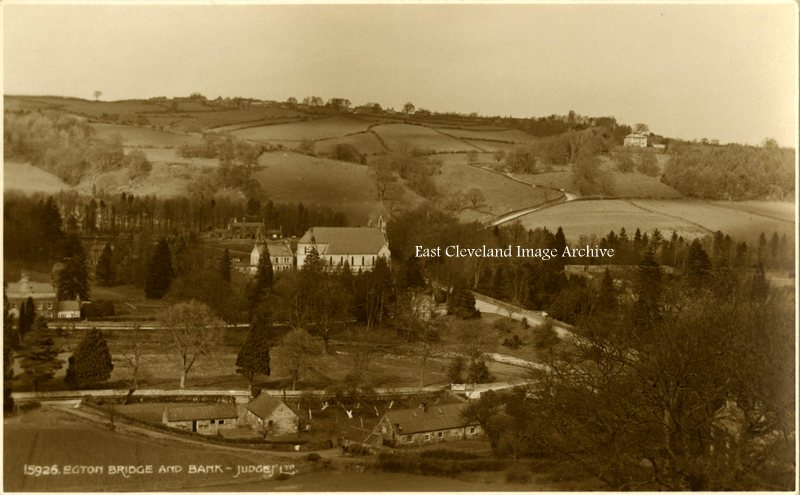
A further Judges postcard view of Egton Bridge, St Hedda’s RC church and the bank (entitled Egton Cliff on maps!) which descends from Egton, at the top of the hill. The view, dating from the 1950s; was probably taken from the road which having crossed the River Esk splits and then leads to Goathland or over the moor to Rosedale.
Image courtesy of Iris Place.
|
|


Recent Comments